
ITEM SPECIFICS
-
Brand
Unbranded
-
origin
Republic of Korea
-
Size(Capacity)
PRODUCT DESCRIPTION
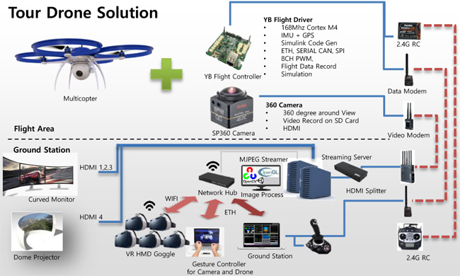
Unmanned Aerial Vehicles(UAV)
Flight Control System
Ground Control System
PILS simulation for developer
Processor in the Loop Simulation before Flight.
Semi-Auto for the unskilled
Waypoint NAV, One Point NAV Enhanced manual flight for unskilled person with Gesture Sensor
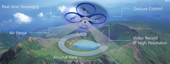
Air Fence for manager
Set a flight area to protect nature resource
Emergency during the flight
Warning emergency situation detect low fuel, bad sensors RTB(Return to Base)
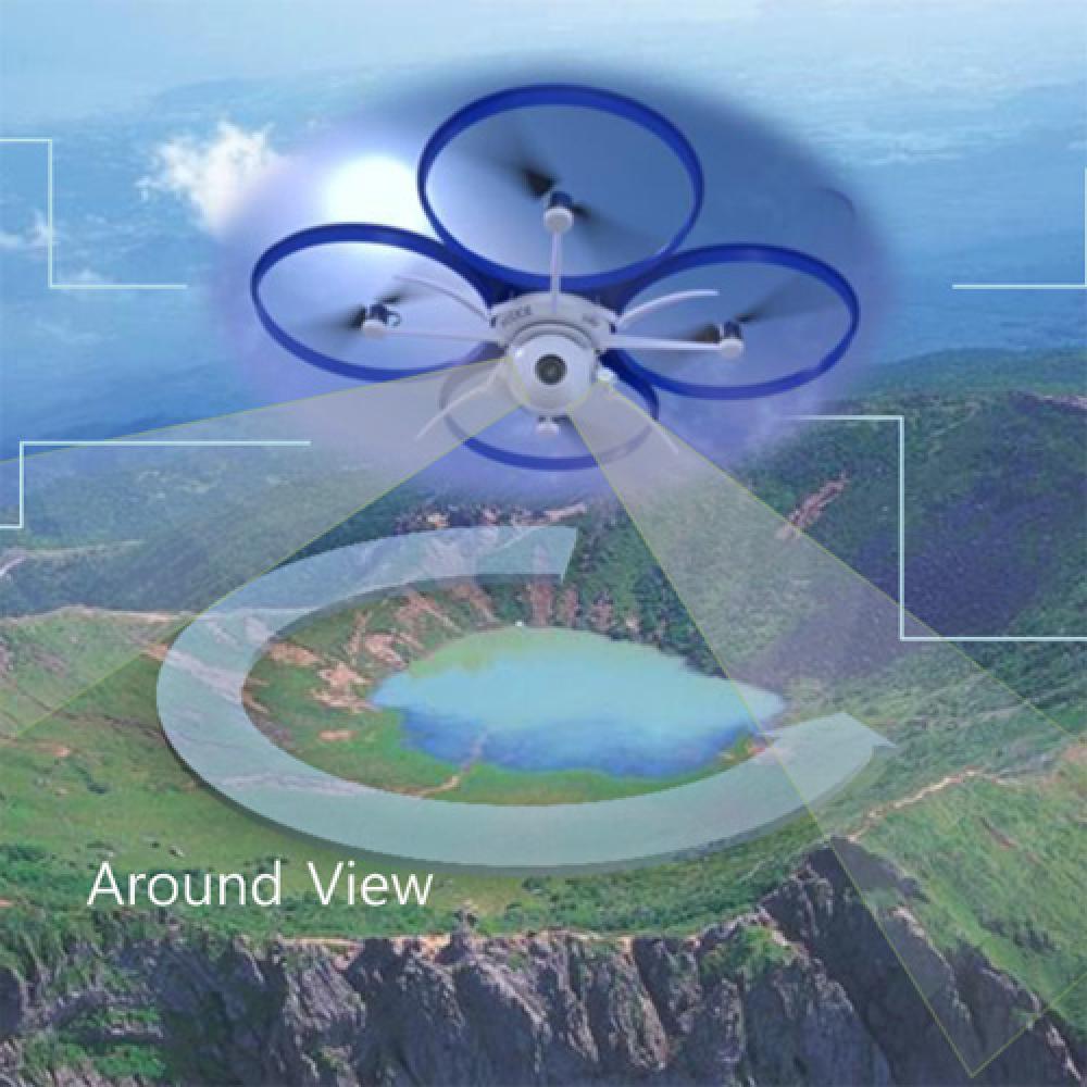
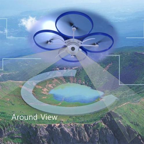
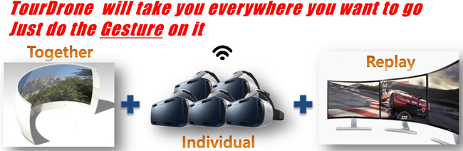
Extremely Immersive scenery view
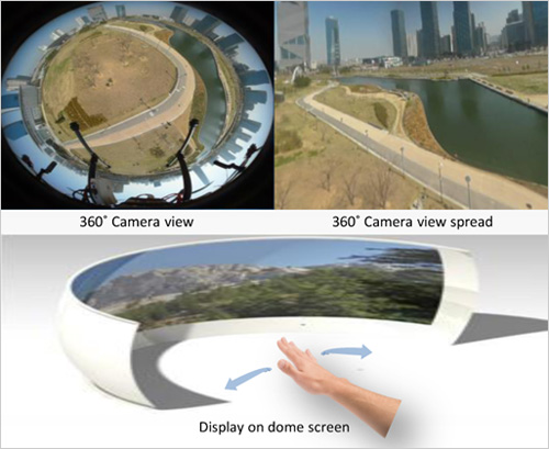
- 360° view Live streaming
- Easy gesture control
-Camera : Line of Sight(LOS)
-Drone : Flight control - Group aviation tourism, WIde view
- Safe tourism : Cliff, Mountaintop, Opposite side of the valley, etc.
- Smart Guide
-Voice guidance, Texture description
-Hyperlink to store or webpage - HMD graphic
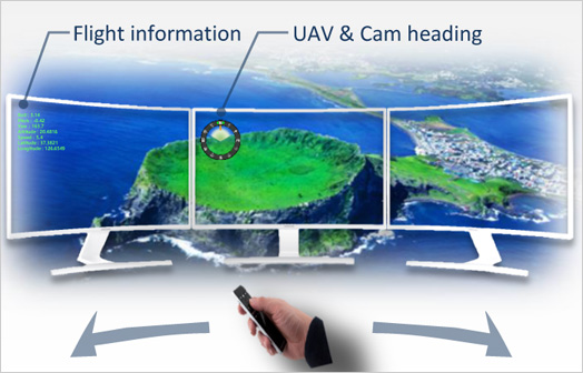
-Drone location(Latitude / Longitude/Altitude), Attitude
-Text & graphic information of LOS
Individual SIghtseeing with AR Goggle
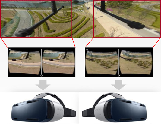
- 360° view Live streaming
- Individual aviation tourism
- Augmented Reality
-Voice guidance, Texture description(future work) - Background musing(future work)
- MJPEG Streaming, 15~30FPS
- HMD graphic(future work)
-Drone location (Latitude/Longitude/Altitude), Attitude
-Text & graphic information of LOS
Flexibly Expandable scenery view
- Replay the attraction video
-High resolution video - Higher resolution than streaming
- Watch viewpoints you missed
-Video px-layer for 360° - Sync with Flight Data File
-Smart guide, shopping-mall hyperlink - HMD graphic
-Location, attitude, speed, image heading, support multi or single monitor(future work)
PAYMENTS DETAILS
This supplier supports payments for offline orders
- Telegraphic Transfer : T/T
- Name : Sungsoo Kim
SHIPPING
Shipping from :
Republic of Korea
- , 인천광역시,
-
- Business Type :
- Manufacturer
-
- Main Product :
-
- Established :
- 2005-03-01
Please suggest a variety of your ideas such as design, impact, enhancements, etc
Captcha Required
Please enter the text on the left image to prevent automatic input.
0 / 4000
질문이 없습니다.
CUSTOMER REVIEWS (0)

COMPARISON TO SIMILAR ITEMS more
- No Items
- supplier level
- MEMBER
- YongBee AT Inc. Seller's Store
- Seller's Store url
- Response Level
★ ★ ★ ★ ★

- Supplier Level
★ ★ ★ ★ ★
- Transaction Level
★ ★ ★ ★ ★
SUPPLIER BEST